 April 1, 2022 will be a huge day in genealogy-land! That is the date that images of the 1950 U.S. population census will be released to the public. (This follows the law that a census cannot be made publicly available until 72 years after the official census day.)
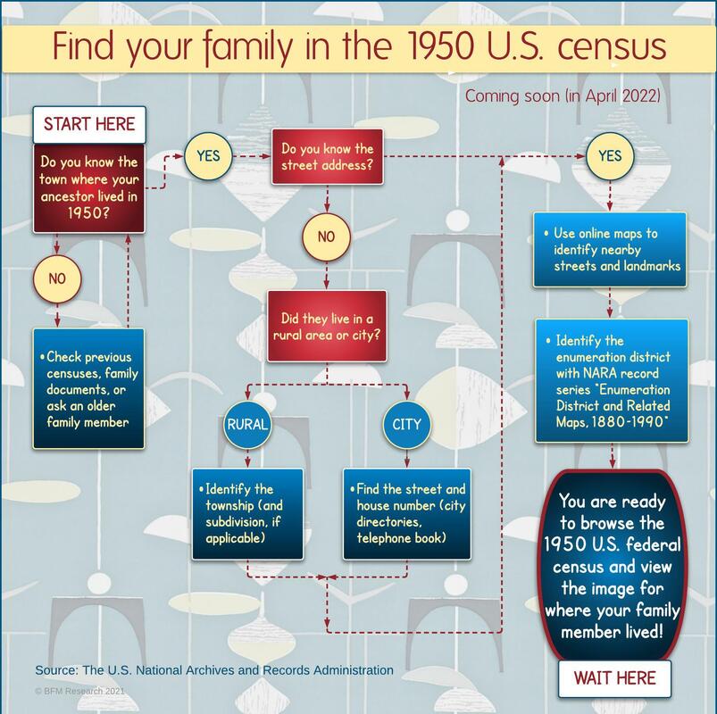
The good news is that you will see images of the actual census pages that the enumerators filled out. The not-as-good news is that they will not be searchable by an ancestor's name until sites like Ancestry.com, Fold3.com, or Family Search create indexes and databases for you. And that will take several months of many people working many hours to get that done. The National Archives and Records Administration (NARA) may use handwriting recognition technology to provide a name index soon after. Still, you can imagine that it won't be particularly accurate. (I mean, I can't even read my OWN handwriting sometimes, so...) You can wait impatiently for months until a searchable database becomes available, or you can do some homework and get the job done much more quickly. The key is knowing the street address of where your ancestor lived that fateful day in 1950. Identify the correct enumeration district (ED), and you will be ready to browse the images and track him down in no time (sort of). My infographic above follows the research process by asking you a few questions and setting you up for success when the clock strikes midnight on March 31! PINPOINT WHERE YOUR ANCESTOR LIVED IN 1950 A street address for a city-dwelling ancestor is like gold here. If he/she lived in the country, then a township or subdivision of a rural area will work. But if you don't know where their residence was, there are ways to figure it out. If you are super lucky, someone in your family might know. Or poke around in the family records you already have for some clues. Hint: if you know where they were on the 1940 census, try following their path with city and phone directories. If the street still exists, you can find it with online mapping tools like Google Maps. If the street is gone or was renamed, seek out historical maps from earlier in the 20th century. Either way, familiarize yourself with main streets and landmarks in the neighborhood because one of those will likely be a boundary line of an ED. IDENTIFY THE CENSUS ENUMERATION DISTRICT (ED) FOR YOUR ANCESTOR'S RESIDENCE The purist's way of determining the ED for your ancestor is to find his location on the original Census Bureau's maps. The National Archives Catalog has digital images of the 1950 census ED maps in the record series, "Enumeration District and Related Maps, 1880–1990." In addition to the political jurisdictions (county, city, township), the maps show roads, waterways, and large properties like cemeteries and parks. City maps often label ward boundaries and other types of subdivisions. The ED numbers are written in orange and have two parts: 2-digit prefix for county and 2-digit suffix for a specific area in that county. Do you prefer the click-and-go method? I can still hear my math teacher lecturing me, "You need to know how to calculate the answer yourself before I let you use a calculator!" The value of that wasn't lost on me, particularly when my solar calculator ran out of power during a test. And I did just give you the tools to determine your ancestor's ED by hand. But lucky for you, tech wizard Steve Morse created the One-Step-Webpages site where the magic can happen much more quickly. On his Unified Census ED Finder page, you can type in as much information you know about your ancestor's location, and the ED will be spit out for you. So, get all your ancestors' 1950 data pulled together now, and you will be ready to roll when the 1950 census is made available to the public. Happy hunting! Additional sources: 1950 US census research guide on FamilySearch How to research census records with the NARA website NARA's 1950 census blog 1950 US Census Bureau History NARA blog about online public access to its records
9 Comments
|

AuthorBeth Finch McCarthy 
|
Website created and managed by Beth Finch McCarthy (2022)